Top

Articles

Fly Fish Food Jimmy's / Articles (Page 3)

Duck Creek in Yellowstone Park


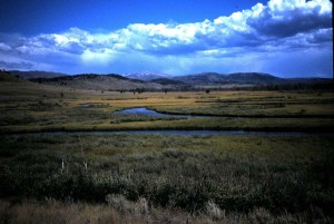
There are duck creeks all over the Rocky Mountain west just as there are elk creeks, moose creeks, and spring creeks. But Duck Creek in Yellowstone Park is special amongst the duck creeks. Situated between the intensely media targeted Madison and Gallatin rivers, it is overlooked by so many fly-fishers. But for those seeking very large trout and owning a high skill level for successful large trout encounters, Duck Creek is the equal of these two famed rivers.  Where one first sees it crossing US Highway 191 about eight miles north of West Yellowstone and just south of the Quake Lake junction, Duck Creek looks hardly worth any attention.  Here it looks like a stream of gradient such as the South Fork of the Madison River crossing US highway 20 west of West Yellowstone, but  in more degraded environs.  But if one takes the turn-off to the right at the Montana State Highway Maintenance Station just to the south of this crossing from Highway 191, one can be in for a great discovery.  On the turn-off, drive past the subdivision and on to the Park boundary indicated by a series of posts. The road bares to the left along the posts and ends at a turn-around.  Flowing past the turn-around on the north, Duck Creek exits the Park to enter a private pond bordering the subdivision.  On the east side of the turn-around one can see a trail going east through the sage brush.  This trail is the remains of an old access road now blocked from motorized travel. To one’s left Duck Creek is partially visible, and its change of character begins to hint at what is ahead.  At the end of the trail, a few hundred yards from the turn-around, a scene of meadow creek splendor confronts the visitor. See the evening scene in the picture above. “Why, thinks the first time visitor, have I not visited this  place before?” “Ah, it is so great to be back, thinks the fly-fisher of much Duck Creek experience.”

So how does one fish this classic meadow stream? Let’s begin with this time of year and discuss other times of the year in future articles.  Have you heard the term ” Henry’s Fork Hunchback” born on the Henry’s Fork in Harriman State Park? The “Duck Creek Crawl” is more appropriate here, for any adult of close to average height or more will be the tallest object in the more than mile-long meadow in view. Within that meadow the creek winds about three miles and has a deep hole with undercuts at every bend. The trick is to bring that big brookie, brown, or ‘bow that can range up to several pounds out of that bend to take your false offering.  It means stealth to the greatest degree with all effort to keep out of view. The further one progresses up the meadow, the smaller the stream becomes, but trout up to very large sizes remain.  Throughout, it means drifting your offering downstream on a long, fine leader, drag-free at the same time as the meager current while keeping out of sight as much as practical.  For the dry fly enthusiast, PMD, terrestrial, and damselfly patterns are the best choices. Do you have a small grass snake pattern? Don’t laugh; you will surely encounter few trout by presenting such, but one you do could bethe fish of the year.  The same applies with a hair mouse. For presenting both, the axiom “fish early, fish late”  applies and it turns out this is the best way to fish Duck Creek with any fly pattern this time of year. There is a bonus for fishing here if you do not mind walking up the meadow about a mile. That is a series of beaver ponds where the creek turns to the south side of the meadow.  Bring your favorite leech pattern to try in these. Above, where Richards and Gneiss Creeks come together forming Duck Creek, further access is not possible as these streams border the west side of a bear habitat closure. So yes, it may be wise to carry bear spray and occasionally give a blast from a claxon horn.  True, the presence of bears help keep down the number of fly-fisher visits to the upper meadow, but in my hundred or so of such visits, I have seen only one grizzly. He was as impressive as any in this region, but caused no harm. Here are a few other thoughts. Wading wet is very appropriate as there are several creek crossings where water is not even knee deep. It is, however, best to stay out of the creek as much as possible because stirred up sand and silt will alert downstream trout that something is amiss and it is time to hide in that undercut.  Bring potable water.  And don’t forget “fish early, fish late!”


Share

Beaver Ponds


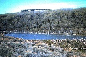
Have you read Osborne Russell’s  Journal of a Trapper? If so, you will see that much of his efforts for beaver took place in country just east of the Snake River Plain. That was prime beaver country, and although diminished somewhat, it remains good beaver habitat today. Of course, Russell was not interested in beaver ponds from the fishing standpoint, except maybe  for an occasional fish dinner.  As fly-fishers, we should be very interested in these which serve as havens for trout in times when low water prevails such as now.  Beaver ponds can range from something not much bigger than a puddle to ones that you can literally put a float tube on. See the pic above? That is one on the upper part of Willow Creek.   With a six-foot tall dam and water at least that deep, fish can winter over in that resulting pond, and with the abundant food supply grow to very large sizes. That other positive aspect of beaver ponds is that they are great producers of food items for trout. Damselflies, dragonflies, forage minnows, speckled dun mayflies, and especially leeches abound within. From adjacent terrestrial habitat comes an array of insects and such bigger items as field mice.  But among these leaches in good number, perhaps are the most important because they are easy protein meaning no exoskeleton, bones, or hair to be digested, just flesh.  How does one judge whether or not a particular pond holds fish? Give them a try, of course, but there are outward signs that help.  Depth is key, so look for it.   An inlet creek of perennial or near perennial flow with little gradient is necessary.  Another is the presence of the food forms identified above. Look also for cover such as the snags seen in the picture above, bank side willows, and tall grasses.

In what regional drainages can one best find these ponds? Take a tip from Osborne Russell’s travels. Willow Creek drainage, especially upper and middle reaches has plenty. So do tributaries Cranes Creek, Grays Lake Outlet, and Brockman Creek. Not too long ago some of these hosted brown trout ranging to double figure poundage.  These fish have diminished because of drought and management policies which favor sustaining native cutthroat trout.  But in a few of these big browns remain with cutthroat growing to large sizes.  Willow Creek drainage is only the western end of great beaver pond country.  Bear Creek and Fall Creek host some excellent ponds. So does McCoy Creek in upper reaches and it tributaries such as Clear Creek.  Further downstream on the South Fork reach of the Snake River, Pine Creek has beaver ponds along State Highway 31. On Palisades Creek, one finds them on the creek just above lower Palisades Lake.  Big Elk Creek is pretty much free of beaver ponds mainly because of gradient.  To the east, Idaho streams draining into the Salt River: Jackknife, Tincup,  Stump Creek, and Crow Creeks all host beaver ponds. Some tributaries such as South Fork of Tincup Creek and Sage Creek are also worthy of attention.  To the south, some Portneuf River and Blackfoot River tributaries such as Toponce Creek and Diamond Creek respectively. Brush Creek a tributary to the lower Blackfoot River has many.  Away from this area, Sinks drainage streams including Beaver Creek, Camas Creek, Little Lost River, Sawmill Creek and Medicine Lodge Creek tributaries have worthy ponds.  In the Henry’s Fork drainage Rock Creek, Partridge Creek, Squirrel Creek and others have beaver ponds.

What is makes a good strategy for fishing beaver ponds. Early in the season before they weed up an intermediate line will get your leech pattern to depth in the large ponds. Throughout the season a floating line works for small ponds.  All these ponds will weed up as the season goes into summer. This makes presentations anywhere with a floating lines best.  Look for overhead cover as described above.  Look for creek channels within the pond for presenting leech patterns.   Fish around inlets and springs.  Black or olive themes seem best.  Just tie or buy your favorites in those colors.  Purple is coming on as an effective color for leech patterns.  Notice I seem to emphasize leech patterns, and that is because of the “easy protein” theory (same applies to earthworms and annelids) but dry damselfly and dragonfly patterns  can be exciting to use.  For sure the most exciting of all is that hair mouse pattern. Swim it along the surface under low light conditions such as twilight if you are convinced large trout are present.  If all this wets your appetite for more information, stop by the shop where we can provide much more.


Share

Bechler Meadows

Bechler Meadows


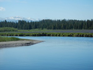
It’s a place of legend, and will stay that way because effort is required to enjoy fishing the river of the same name and Boundary Creek also within.  Both are classic meadow streams, and both can be quite demanding : Bechler River as much as the Harriman State Park reach of the Henry’s Fork, and Boundary Creek as much as Jackson Hole’s Flat Creek. But there is a major difference. Whereas that part of the Henry’s Fork and Flat Creek can be very crowded in season, there are times when you just may have the streams in Bechler Meadows all to yourself!  The price you pay is the three and a half mile walk minimum, then walk-around fishing, and finally the required walk out. I have noticed that this means as much as ten miles in a day of fishing.  But when you are at these streams at the right time, you will likely have an unforgettable fly-fishing experience.  Here is what happens to attract fish to feed on or near the surface: after run-off leaves the waters, and earthworms no longer plentiful enough to provide the major part of diets, fish experience a progression of aquatic insect emergences. That progression begins with an in-stream emerging yellow sally stonefly, then that of  mayflies. That begins with gray drakes crawling from sloughs out in the meadows. Spinners of these are blown into the stream about the same time that PMDs begin emerging from the streams. The PMDs begin with those of a large size (#14), but with time  seem to quickly reduce to the #18-#20 range.  While all this is going on giant and golden stonefly adults are blown in from the canyon reaches above and below ( the same happens in the Harriman reach of the Henry’s Fork). Then in normal water years around mid July,  green and brown drakes take over as the major aquatic insect species emerging.  Most of the activity will be in afternoon hours as waters must warm to  necessary temperatures.  So that is a major difference from the similar water of the Harriman reach of the Henry’s Fork.  Take your favorite patterns for all of these.  Use the same sizes, and balanced system as you would for the Harriman reach. But there is no need to worry about being there early for the bulk of action; stock up with a big breakfast in St. Anthony, Ashton or Island Park, off the lower Mesa Falls Scenic Route take the Green Timber (aka Cave Falls Road) Road to the Bechler Ranger Station Road leaving on left  just inside the Wyoming border. Park at the station where a crew of rangers is always present. Let them know of your fishing plans (fishing permits are available there), then head for the trail to the meadows but arrive in the meadows by late morning.  Let’s look at hazards. Until the end of July you will experience a mosquito density in the timber like nowhere else outside of Siberia. That makes a good supply of DEET necessary.  Drink water out of the streams here at your own risk. Giardia can be anywhere, so either pack your water or a water purifier. And drink water like there is no tomorrow, because staying hydrated is a must for comfort especially during the walk back to the ranger station.  Do you believe in using sun screen and covering up as much as practical? You will if you get a burn from being out in the meadows in the intense sunshine.  A rain coat is a good idea, and it is your choice whether to wade wet or pack in waders.  Need more information or need items to make your visit a fly-fishing success? stop in and chat strategy, equipment,  get a Yellowstone Park fishing license, and information with us. One more thing. see that picture above? That means do not forget a good camera.


Share

Cardiac Canyon-Bear Gulch


Bear Gulch


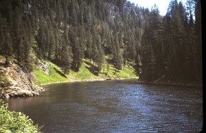
Here is another Cardiac Canyon location sure to get you away from the crowds. It’s now a bit late in the year to fish the big stonefly hatches here, but consider putting it on your “have to visit” list for next year’s stonefly season.  If you do, you could witness one of the densest giant stonefly hatches anywhere as well as rainbow trout as large as anywhere else on the river with a few brown trout to boot.  To get there, take the Mesa Falls Scenic Route (Idaho Highway 47) east from Ashton. Drive past the Three Rivers area a few miles to an ample turnoff on the left where the old Bear Gulch Ski area use to be.  From here an old service road passes an abandon ski lift and ends within one hundred yards of the river.   That distance is completed on a good trail, and here the river looks almost like a big pond.  It hosts some of the biggest trout in the entire river. On getting to the river you will hear the roar of rapids above and below this almost still water.  Above and below the river  cascades, but holds runs and pockets good enough to hold numerous trout. Some boats holding eager anglers may come through, but not in numbers found in Box Canyon, the Riverside Campground to Hatchery Ford section or especially the Warm River to Ashton Reservoir section below. This time of year you can enjoy an afternoon caddis hatch dense enough to cause what Mike Lawson labels “bronchaddis.” You will also experience fish taking PMDs in various parts of the life cycle. Presenting a dry golden stonefly pattern could still be effective.  But coming soon is a most interesting way to enjoy the big and vigorous trout present.  That would be with terrestrial insect patterns, and afternoon are the best time of day to be here.  Soon hoppers in uncountable numbers will abound the grassy slopes.  Ants and beetles will be scurrying everywhere. And those big trout will be near the banks waiting to pick all these off.   All this activity will continue  maybe to the first week in October.  From where you first reach the river a trail goes upstream along the steep bank.  I prefer to follow this upstream and fish the bank side runs, pockets, and the overhangs this time of year. Yes, there is good water downstream, but in my experience going upstream you will encounter more of it.   Go far enough and you could approach the fabled “Surprise Falls”, that capsizer of  unobservant boaters.  Speaking of boats, after the giant and golden stoneflies go through, you are likely to see very few boats, and those you see are mainly sight seeing tourists or kayakers coming down from the Grandview access just below Lower Mesa Falls.   Speaking of walk-in anglers, you will also see fewer of them after the big stoneflies have gone through.  I usually wade wet during summer months, but you can easily pack waders in by choice. At least a six-weight system with stout (3X) tippet is best for the powerful water here.  Bring that camera!

Share

Cardiac Canyon of the Henry’s Fork


Hatchery Ford

The Henry’s Fork could be the most famed trout stream in our country.   That being the case it is a huge destination, and for good reason.  It is one of my favorite rivers, but with its reputation I tend to seek out the the less visited reaches. My favorite part of this great river is in Cardiac Canyon which begins just below Riverside Campground and ends at the Warm River confluence.   Within this reach are  a number of places to access the river, and the best of these from an overall fishing experience require some physical effort.  Two locations, in particular are my favorites: Bear Gulch and Hatchery Ford. Let’s look at the Hatchery Ford access for now and talk of the Bear Gulch later.

A boat ramp  is present on the east side of the river here.  It is the last place a boat from the Riverside Campground access can leave the river before entering the perilous waters beginning not far below.  Because of relatively easy access, the boat launch is increasingly used by walk-in anglers. I prefer to access the Hatchery Ford area from the West Hatchery Ford Road off  Highway 20.   It’s a bit tricky to zero in on getting to the river, but if you travel down the road almost exactly a mile you come on your left to some boulders placed to discourage motorized access down the dugway to the river.  Once you access the river after a quarter mile walk downward the river comes in view making a big bend. Below it drops swiftly to the Sheep Falls area.  Above, for about a mile the gradient eases and becomes more hospitable for fishing, but either direction on the river will get you into great fishing. Walking upstream you skirt a cliff at the bottom of which is a long, deep run which hosts trout that rival in size those in Box Canyon. These large fish reside here until an event such as the giant and golden stonefly hatches bring them out.   That event is happening at the time I’m writing this and it is an excellent time to fish here.   That means right now for the next few days fish with big dry patterns that imitate the big stoneflies.  If you cannot try it at this time try it in about a week to ten days depending on weather conditions.  Fish will have digested eaten bugs and be looking for more.  If you cannot try the river during this time, come back during the terrestrial season with hopper patterns. Try at the head of the long, deep run or go to the broad flat water above and try the same strategy you might choose for the earlier stone fly hatch. That means concentrate presentations around overhangs, rocky or vegetated banks, and boulders out in the stream. If you cannot  fish here during the terrestrial season, come back in October and November (weather permitting) and present streamer patterns in the same manner you would use in the Box Canyon.  In any of these time periods you have a chance at those famous big Henry’s Fork rainbows. And in the fast water they are sure to test your skill at handling large trout.

Share

Horseshoe Lake

Horseshoe Lake

Grayling are tough to find in eastern Idaho. Your best chance of encountering them is in some mountain lakes further west toward Copper Basin and such high locations where they are present because of IDF&G stocking programs. You can also encounter them as wild fish in Yellowstone Park’s Cascade, Grebe and Wolf lakes where occasional individuals escape to the Gibbon and Madison rivers below.  Not far away in Montana wild grayling are also present in upper reaches of the Red Rock, Ruby and Big Hole river drainages.  Fishing all of these require some travel time.  There is, however, a near-by location in eastern Idaho that hosts a put and take grayling population.  That is Horseshoe Lake east of Ashton.  Take the Mesa Falls Scenic Route  (State Highway 47) east out of Ashton to the Green Timber Road, also known as the Cave Falls Road.  Travel east into Targhee National Forest past the Porcupine Creek and Rock Creek crossings.  About a mile past the Rock Creek crossing the signed road to Horseshoe Lake leaves on the left.  It is fairly well maintained and suitable for two-wheel drive passage after drying out from winter snows.  It accesses the north side of Horseshoe Lake and goes on to a youth correctional facility on the east leg of the pond.  Primitive camping locations dot the northwest shoreline where only primitive boat launch facilities are present.  Motorized boats are not allowed on the lake which has no surface outlet and inlet.  Float tubes and pontoon boats are the best bet for fishing here as the shoreline is mainly swampy or timbered.  Along with grayling,  put and take rainbows are present in the lake.  Midge activity is ongoing most of the season, but sometime in June damselflies will emerge to be followed later by speckled duns.   Beginning in the early season with damselfly nymph patterns, moving to dry damsel patterns and on to speckled dun life cycle patterns one can attract grayling the entire season.  Lilly pads dot some of the shoreline, and these locations provide a tip of where to concentrate fishing efforts.  Get out in front of the pads,  that host copious insects, and watch for active fish. Light weight equipment with a floating line is the name of the game here, and I really enjoy presenting with my two-weight system whether it is small nymph, emerger or dry patterns.  When grayling are active catching a few dozen is possible.  A braggin’ size grayling here is a bit over a foot long (but they are beautiful!) meaning that with their small mouths, small flies (#14 on down) are necessary.  You might encounter as many rainbows as grayling, and they range  a bit bigger.  If you camp here, you also have the option of a scramble down the rocks to Robinson Creek where few people fish. It’s a bit of a tough go, but company on the creek is doubtful.  Pocket water cutthroat and brookies will respond well just about any time to your dry and wet offerings here.  But if you are looking for some unique fishing in this part of Idaho, Horseshoe Lake’s grayling population offers it.

Share

Idaho’s Salt River Tributaries


Idaho’s Salt River Tributaries

Extreme eastern Idaho is relatively unknown for many fly-fishers because bypassing the South Fork and such as Big Elk and Palisades creeks is  almost impossible to accomplish.  If you can “tough out ” passing these great fisheries and head south down US Highway 89 in Star Valley, a selection of great small streams await. All flow east into the Salt River, and each seems to host the same: browns  in numbers varying stream to stream and cutthroat in good numbers. In fact, these can be considered cutthroat refuges.  Are they Snake River fine spotted or Yellowstone strains?  Likely a mixture of both as in other Snake River drainage places.  You could enjoy fishing an entire weekend trying your skill on Jackknife, Tincup, Stump and Crow creeks.  Tincup Creek is mainly a riffle and run stream paralleled by Idaho State Highway 34.  Being close to this main highway it is likely the most heavily fished, but that isn’t saying much compared to pressure on South Fork and Palisades Reservoir tributaries.  The other three have county or forest service roads nearby making for easy access.  Jackknife, Stump and Crow and their main tributaries are mainly brushy meadow streams.    All host beaver ponds of holdover quality that should catch your attention if you seek big trout.   The picture above shows Stump Creek just off the Smoky Canyon Road crossing.   Note the beaver pond near the center.  Not far upstream of this location a fly-fishing friend of mine caught a 27-inch brown  a few years back.  He sent me a picture, so I have to believe, assuming this was the true location.   Stream character in this picture is typical of these three streams. Visiting during the springtime (June into early July) mayfly emergence peak can be very rewarding.  All have the usual mayfly arrays emerging including gray and green drakes and PMDs.  If action is slow one one stream, another is reasonably close by. Visiting before the mayfly peak after run-off subsides and beaver ponds are repaired, trout  foraging for leeches can bring very satisfying action.    During summer presenting terrestrial patterns is the best way to find success.  Do not let the size of these streams disappoint you because trophy fish reside here.  You must be stealthy to the utmost.  Or you could come back in the autumn around the end of September when streams remaining connected to the Salt River host run-up brown trout running to sizes respectable in any river.  The trick to success at this time is stealth to the point of appearing to be a natural piece of the surroundings is key.  Stump and Crow creeks would be your best bets to encounter these run-ups ranging up to near six pounds.   Are you getting into the Tenkara presentation technique that is proven so effective for small waters? You could not ask for a better location for trying it than on these streams.  And almost anywhere you try these streams you will solitude to appreciate .


Share

Harriman Fish Pond


Harriman Fish Pond

Not only is this a pond of legend, it is also among the safest of public still waters to be found in the Island Park area.  It was created by the Harriman family in the early twentieth century as a place to take Railroad Ranch guests fishing.   The family dammed Osborn Creek and a couple of smaller intermittent creeks to form it.   IDF&G has used it on an experimental basis to test trout suitability.  It is not very deep, but rich in nutrients, so over the years it has gained a reputation for producing huge rainbows and trophy-sized brook trout.  It has endured misuse from dewatering and bank erosion, yet properly maintained and kept at full pool year round, it is a superb fishery.  If you are familiar with fishing the Henry’s Fork from Wood Road 16 access, you go by the pond to the south a few hundred yards.   That creek entering the Henry’s Fork just above the access is the outlet from the Fish Pond.  I’m not going to say anything about the fish in that creek below the pond! You can get to the Fish Pond from the Mesa Falls Scenic Route.  Drive down the Route from Highway 20 just above the Osborn Bridge.  A bit more than a mile on the right the access road to river near “Pine Point” goes to the right. Turn off here and take the immediate left, a primitive road that takes one to the north end of the Fish Pond, and on to the west end dam.  You can fish from the dam without needing wading gear. To fish effectively anywhere else here you will need to get out on the pond with a non-motorized craft because the pond bottom is mostly deep silt.  But the pond is ideal for float tubing or pontoon boating, and launching such from the north end is easy.

Fly-fishing season on the pond begins as soon as ice comes off and the primitive access road to its north end is passable. I have fished it as early as the end of April after a winter of scanty snowfall.  During the early season any pattern resembling a leech or dragonfly  nymph works.  When midges begin emerging in number, life cycle patterns for them work until resident fish become filled. When that happens, go elsewhere.   After the fish are over this “midge binge” try speckled dun life cycle patterns.  By then, however, you may need to fish  mostly on or near the surface because weed growth clogs so much of the pond that fishing wet is mainly good for dredging up weeds.  Any time you fish here a floating line is best because for the most part the pond is so shallow.  There is some deeper water in front of the dam on the west end and along the creek channel in its middle.  I usually avoid the pond as July approaches because fishing there slows.   But I come back very late, as late as the first of November when weeds are dispersing, and I present midge life cycle patterns or a small (size 12-14) bead head peacock leech.  This is when I have caught my largest fish, but one can certainly encounter large fish here any time during the season.  These  big ones are a bit tougher to encounter in recent years because hatchery catchables are now present, but one benefit of  those hatchery catchables is that if they hold over, they can become big guys.  So if you are looking for a chance for a fish of the season under safe conditions compared to a wind-blown Henry’s Lake or Island Park Reservoir, or you have youngsters or have physically challenged folks wishing for the same, put this spot near the top of your destination list.

Share

Birch Creek

It is now timely to give this great little stream some attention.   That attention is appropriate for several reasons.  Access, proximity, reliably aggressive wild trout,  put and take fishing, reasonable solitude, and natural beauty are some.   Also Birch Creek is ready for fishing right now.  From the Snake River Plain this creek is about an hour and a half drive  at the most over good highways. Little traffic can be expected going and returning from it.  Believe it or not, Birch Creek is a spring creek in that it originates mostly from springs in the Kaufman area. From here it becomes  a small but classic desert stream.   Below Lone Pine resort Birch Creek flows mostly through public land, and it is here where weekenders congregate to fish, camp, and ride. Thus IDF&G generously supplements the wild fish population here with hatchery catchables. The result is that the wild fish mostly move out to the diversion below to escape piscatorial crowding and human hub-bub.  For sure one can encounter good fishing here, but usually under less tranquil conditions.  If one travels upstream past Lone Pine, Birch Creek is to the left and on private land.  But this land is under agreement  for public access and as such is designated a “family fishing area” through the generosity of its owner.  Signs at either end and the middle proclaim this. Access here is walk-in with distances from parking varying upwards from a bit less than one hundred yards.  Fencing limits intrusion by cattle, so degradation is minor.  The stream in the upper end of the area runs through broken willow patches with undercuts and surprisingly deep holes and runs.  Throughout the area one can see superb in-stream gravel beds that host aquatic insects as well as offering spawning locations.  Rainbow and brook trout, introduced many years ago, inhabit the creek  in good numbers.   No need to supplement trout populations here!  This is high country, so it takes a while for Birch Creek to regain heat lost through radiation at nighttime and early light.  That means aquatic insects become most active around mid day, and the same goes for the resident ‘bows and brookies.   So if you intend to fish here, enjoy a  hearty breakfast and leisurely drive to arrive  about then.   Hip waders are all that is necessary to walk around the creek in the family area, and during the heat of summer, wet wading is not out of the question.  I have a two-weight rod which is ideal for small streams, Birch Creek included.  I use a floating line and nine-foot leader tapered to 5x, and I have a ball catching brookies and bows ranging upward to a rare sixteen inches.  They are full of fight and eager as can be. This time of year caddis,  midge, isoperla, and BWO life cycle patterns work.    So do traditional attractors in small sizes.  A few golden stoneflies are also present.    As summer comes on any traditional terrestrial pattern works well.

Experience tells me that large rivers tend to intimidate entry level fly-fishers.  Small streams  are almost like a laboratory situation where all things are in a smaller scope and more easily observed.  That means small water is more quickly understood  with respect to realizing where fish hold within, where they move to feed, and where they seek cover.  Essentially all these are more “concentrated” in a small water siting.  It also seems that trout in smaller waters are inherently more aggressive when feeding is considered.  This results in a consistency in feeding that larger waters do not always offer.  It follows from this that the fly-fisher will have more chances per given amount of time to learn how to respond to  feeding fish.  Thus it is to a small stream that I take or recommend to a rank beginner, and Birch Creek is one of the best for this purpose.   Afterwards it is up to that person to  take lessons learned to be sharpened and expanded on through fishing larger waters.


Share

Paul Reservoir


Paul Reservoir

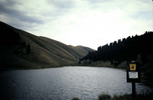
This one is easily driven to, but is off the beaten path.  Go north on Interstate-15 from the Snake River Plain past Spencer.  Just before you come to the Idaho-Montana border, turn off at the Humphrey exit. Go left under the Interstate, then right onto a gravel road. There isn’t much out here, just a ranch or two as the road makes a big arc just beneath a mountain range that marks the Idaho-Montana border, also the Continental Divide.  For a while you do not see any water, just high desert, and likely begin to wonder if this is another “wild goose chase.”  Then to your left a creek appears and you begin to cross small tributaries.  This is Modoc Creek, and it is loaded with brookies of which a nine-incher is a braggin’ fish.  Further on the road fords a few other tribs, then climbs a rise.  You have come a bit over twelve miles when Lo and Behold, that rise is a dam, and Paul Reservoir is behind it.  It owes its presence to the need for water in the arid valley below.  Stock need it, and without the stored water, not enough hay could be grown to support them. Look around at this gentle little reservoir in a hollow.  One side is sage brush covered slope, and the other is a pine forest hosting a few primitive campsites.  Here is a great place to take a physically challenged person or introduce a youngster to still water fishing.  From the dam launching flotation gear is easy, or one can simply fish from shore and nearby.

So what does this oval shaped reservoir, about a third of a mile long, host with respect to fish?  IDF&G keeps a good population of cutthroat trout within.  Some years the population is better than others.  The normal aquatic insect cycle  takes place here.  Midges can emerge throughout the season. Dragonflies begin theirs early followed by damselflies then callibaetis which go from mid to late summer.   Resident leaches and snails become easy protein for the hosted cutthroat.  What about those hosted cutts, you ask?  They are usually co-operative when one presents imitations of the previously mentioned food forms.   So a lightweight outfit such as a four-weight seems to nicely apply here.  So does a nine-foot leader of four or five X tippet.  A floating line or an intermediate line is sufficient.  However, I’ve never caught a cutt here over fifteen inches!   That’s contrary to what an old cowboy told me one day while I was having rare, but unusual luck fishing callibaetis emerger patterns near the dam.  He watched me for a  while from where he was tossing a bobber and night crawler, then approached. “Looks like you’re  really gittin’  into em, but them’s a bit small ( which was true!).”  “See that, there point up the reservoir?, he gestured. “Got me a nineteen-incher there a week ago.”   All this after no one I talked to had caught anything over fifteen inches!  So I knew what was going on; he wanted my location!  So just to frustrate him, I continued to present and catch fish.  He walked away to a spot a quite bit closer to me than where he began.  In any case not many folks fish here, and you cannot find a safer still water place for a youngster or a person with particular needs to fish.   Just be ready to eat a bit of dust along that gravel road when you leave or return to Interstate-15!

Share