Top

Author: Bruce_Staples

Fly Fish Food Jimmy's / Articles posted by Bruce_Staples (Page 212)

Beula Lake

Beula Lake

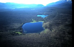
See that lake in the foreground of the “lookin’ south” areal  picture above?  That’s Beula Lake in the southwest area of Yellowstone National Park.   It is also one of the Park’s largest lake (a bit over 100 acres)  hosting Yellowstone cutthroat trout as the sole salmonid.  You cannot say that about larger Park lakes such as Yellowstone and Heart because they also host lake trout.  Trout Lake also hosts cutthroat-rainbow hybrids.  If I were to take a fly-fisher asking to catch cutthroat trout somewhere, especially in a back country setting, Beula Lake would be a top candidate for catching one.

Again, let’s look at the  picture above.  The trail head to Beula Lake is on the Ashton-Flagg Road at the east end of Grassy Lake Reservoir. You can see the trail’s trace towards the right through the skinny jackpine forest in the above picture. It ends at the southwest corner of the lake, a distance of 2.75 miles.  The first half mile from the trail head is uphill, but the rest is flat until you drop about 100 yards to the lake. There is a way to avoid this uphill pitch, but it is best described here in the shop.  That’s Fall River coming  into the southeast side of the lake. Fall River exits the lake at the northwest corner cascading down to flow through the first of stair-step meadows on exiting the Park and on into Idaho.  The elevation here is almost 7500 feet, so being in reasonable shape for the walk is advised.  There are three primitive campsites along the west shore of the lake.  Any one  of these can be used for an overnighter through the Park’s back country reservation system, but a day trip is totally practical.   Now let’s talk fishing.

The season here begins as soon as the USFS opens the Ashton-Flagg Road to traffic. That means after the road is dried. This is big snow country, so opening usually happens late in  June.  Much of Beula can be fished from the shoreline.  Just follow the fisherman trail around the lake to one of the several locations with shallow wading and allowing  back cast room.  Waders help, but are not necessary.  Beula cutts are not particular; any of your favorite small or medium sized  bead head nymph or leech patterns will attract cutts averaging 10-16 inches, but ranging to a bit over 20 inches.   A floating line and nine foot leader with  3-4X tippet  is all that is needed for presentation.  Damselfly action can be expected by the end of June, and speckled duns begin emerging in July.  So life cycle patterns for these two insect types work well any time, and the gulper fishing when they emerge can be terrific.  I’d mentioned wading as being effective for Beula, but if you are in good enough shape to pack a float tube in, you will have even better fishing.   Insulated waders may be best  for the water temps in the high fifties in degrees Fahrenheit.  Get  in front of the lily pad beds and pitch flies back towards the lilys or go to the inlet for non-stop action.  Thirty to forty fish days are common this way.  Again, going to the picture above, you can see Hering Lake  just to the south of Beula. You will need a float tube to fish Hering effectively, but your reward can be cutthroats ranging  to over four pounds.  But that is not every year.  Hering is not as hospitable as Beula, and trout get trapped in it when water connecting the two lakes recedes in springtime.  Some years only a few fish get trapped in Hering,  but competition is lower here , so they grow to larger sizes.  By September another food form is important on these two lakes.  That would be from the ant swarms that frequent the area.  When they fall in good numbers onto the lake surfaces, trout key on them with enthusiasm.  Around the end of September to the first of October the season begins ending here.  That is mainly because of weather.  Rain or snow storms can make the Ashton-Flagg Road tough for other than four-wheel drive vehicles, but when blue bird days extend into October, Beula (and Hering) can be spectacular fishing.  Just keep an eye on the sky for a change in the weather.  Any time you venture here bring potable water, ultra violet protection, and a reliable raincoat.  You will be for a unique and great back country fly-fishing experience.

Share

Damage Potential to the Henry’s Fork at the Grandview Access

Anglers treasure the reach beginning just below Lower Mesa Falls Campground and ending at the Stone Bridge below the Warm River confluence. Waters of the reach host bountiful rainbow and a few brown trout with individuals ranging to several pounds. During springtime large stonefly emergences one of the most popular float and fly-fish trips on the Henry’s Fork is through here. From here also begins a water trip to experience one of the most remote reaches of the Henry’s Fork. This reach of the Henry’s Fork is also much valued by wildlife photographers, rafting enthusiasts, and sightseeing tourists. For several decades, beginning in the mid twentieth century, its use has been a significant part of Fremont County economy. Users rent lodging and vehicles, hire guides, and patronize eateries and other retail outlets within the County. Access to float the river here begins just below Lower Mesa Falls Campground and requires portaging boats, rafts and such for a few hundred yards down a steep and erosion prone slope. Through decades of use over multiple descending routes the slope has suffered erosion to the degree that sediments from it threaten to enter the river to foul water quality and fish habitat. Finally observing damage to the slope through portaging all types of boats downward over these routes, but realizing the public popularity of its use, the United States National Forest Service (USFS) studied potential here for environmental impact. Results of the study indicated that a trail down the slope, not to quicken descent, but to establish a single pathway for portaging soft-sided boats only will minimize chances for sediment eroding into the river. Hard sided boats, usually weighing much more and being more rigid than soft sided boats, dig deeper into the slope and move down it more quickly thus increasing potential for erosion. The USFS therefore established the lowest impact pathway with maintainable water bars down the slope to the river. The USFS also provided soil for plant material to re-vegetate the slope that would provide a natural barrier for impeding sediment from entering the river. The USFS will monitor the effects of use on this pathway on the slope. Although this is a hazardous route to the river and not advocated by the USFS, plans are to keep it open after discussions with fishing guides and other users. Despite establishment of the restrictive trail down the slope, it now appears that some users are pioneering trails to portage hard sided boats down to the river. Such actions make increased potential for sediments to enter the river. In an effort to prevent misuse down the slope, the Snake River Cutthroats and the Upper Snake River Fly-Fishers of Idaho Falls and Rexburg respectively are combining to establish signing at the top of the established pathway to indicate that restrictions are in place and the reasons for them being established. Members of these clubs and Trout Unlimited encourage other anglers and users to honor the restrictions here and to assist the USFS in policing the established trail. Any observed violation of this trail to the river should be reported to the USFS Ashton District Ranger Station: 208-652-7442.

Share

Aldous Lake


Aldous Lake

 One August day about twenty years ago I traveled with wife Carol and Jessie our Lab to the Aldous Lake trail head north of the Clark County ranching community of Kilgore.  Our plans were to spend the night away from civilization, relax, and do some hiking and fishing.   We packed overnight camping gear, float tube, waders, fly fishing equipment, and enough for a few good meals during the stay.  On arriving at the trail head around late morning, I curiously noticed a  parked sedan.  It sported Utah registration plates and rental car identity.  We geared up, hiked the mile and a quarter up to the lake and saw a lone float tuber on it.  We set up camp and noticed cutthroat trout rising as expected to emerging speckled duns on the lake.   I donned waders, strung up with a speckled dun emerger pattern, hopped into the float tube, and paddled out on the lake.  Catching was easy, and I began comparing the experience with the lone float tuber.  To my surprise he responded in a thick New York accent.  How in heck did he find this place!  So I had to ask how because this remote little lake rich in cutthroat trout is off the beaten path.

” I came to Idaho to fish the Henry’s Fork, but crowds around the Last Chance-Harriman offered little solitude.  So I stopped at Mike Lawson’s Henry’s Fork Anglers asking for fishing with solitude.  They suggested this place, so I rented a float tube and fins, picked up some speckled dun patterns, and here I am.   I got here a few hours before you and have had some of the best trout fishing of my life.  Problem is I gotta leave soon to take this gear back to Mike’s, drive to Salt Lake, turn in the car, and catch an early morning flight back to LaGuardia.  Sad to be leaving such a great time.”

Having a great time catching cutts ranging to around twenty inches was no problem that day, and doing so without any other anglers around was a real treat.  Aldous Lake, no more that a pond, offers that experience if you are willing to pack a float tube and waders for a mile and a quarter up a well-maintained, non-motorized trail. You get there after traveling Interstate-15 to Dubois, Idaho. There you exit and go east on county highway A2 to Kilgore.  From there you hang a left ( go west) to the nearby East Camas-Ching Creek Road, take a right and follow the road to its end at the trail head.  From the Island Park area, take the Yale-Kilgore Road west to Kilgore.  After a short but exhilarating hike, you come to the lake on the south side of the Centennial Range, and just below the Continental Divide.  Yellowstone cutthroat trout inhabit the lake.   Some limited spawning occurs in the outlet, so from time to time IDF&G enhances their population.  All you need to enjoy these cutts is a floating line, long leader, and reasonable physical condition.  If you choose to wade, bring your roll casting skills because most of the shoreline is forested.  But a packable float tube gets you onto the lake to enjoy cruising cutts picking off emerging damselflies in late June or speckled duns emerging from late July into September.  The same cutts will take small leech or scud patterns just about any time.   The mostly uphill walk to the lake pretty much guarantees only a few anglers being present, and even fewer will pack a float tube.  Bring potable water, a shielding hat, and sun screen.  You will be in for a near wilderness experience.

i

Share

Shoshone Lake

Shoshone Lake


It’s the largest roadless lake in the lower forty-eight states. That is thanks to being in Yellowstone National Park.  At a bit over twelve square miles it is a distant second in size of Park lakes to Yellowstone Lake.  Historically barren of salmonids until the late nineteenth century, it was stocked with lake trout from the Great Lakes and with brown and brook trout.  So well did these adapt that for a while a commercial fishery operated on the lake to supply Park hotels with table fare.  This activity was stopped when fish stocks in the lake diminished early in the twentieth century.  Later, power boats were eliminated from the lake  in an effort to maintain its pristine character. That restriction, thankfully, remains to this day.

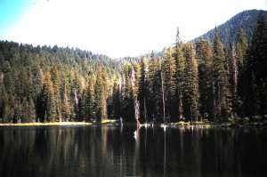
Because Shoshone is roadless, trails and a river trip up its outlet Lewis River are the only means of approach. The water trip requires crossing Lewis Lake and traveling up the river in a non-motorized manner.  Several trails go to the lake,  the longest being from Bechler Ranger Station or even Old Faithful,  trips of over twenty-five  miles to Shoshone’s west end.  To the east end and outlet, a trail begins just north of  Lewis Lake, follows along a ridge above the river and ends near the Shoshone Lake Ranger Station, a distance of about five miles.  The shortest trail to the lake begins off the Old Faithful-West Thumb Junction road and follows Delacey Creek to the lake, a distance of three miles.  This is the easily traversed Delacey Creek Trail which leads close to one of the best fishing spots ( see the above picture) on the lake. Only problem is the angler needs to pack a float tube  or similar floatation device to get out in the lake to realize the superb fishing  at this location. Shoreline fishing is also possible at this location, but a good day doing so might result in on one or two fish. Out in the lake here, especially about one hundred yards, along the eastern shoreline,  are weed beds which host food forms such as leeches, scuds, aquatic insect life cycle forms, and forage minnows. These weed beds therefore attract numerous foraging  juvenile lake trout, brown trout and relatively rare brook trout.  All the visiting fly-fisher must do is paddle out to these and use a full-sinking line and moderately strong (2X) nine foot leader to get down to these beds, usually around fifteen feet below, with patterns that imitate these food forms, and action will come.  Action comes from juvenile lake trout, usually measuring between seventeen and twenty-two inches, and some of the most beautiful brown trout alive.  These range up to twenty-five inches and fight as well as their lower elevation brothers and sisters.  When usual wind is not roughening the lake surface, fish can be seen around the weed beds in the ultra-clear water.

There is also another “must” for fishing the lake in this manner: insulated waders or enough layers of clothing underneath waders to keep body parts in the forty-five degree water warm enough to function.  A good shielding hat for sunlight protection and a raincoat in case of afternoon thundershowers should be packed.  While on the lake mosquitoes are not pesty,  but they can be on the trail.  So a repellent high in DEET content is recommended.  If one packs food, this must be hung in trees to keep away from bears.  Better yet, take  food items out onto the lake.  Bringing potable water is not required, but is recommended.  A current Park fishing license is required, and so is a non-motorized  ($10 in 2012) boat permit for using a float tube or similar device.  Both permits can be obtained at Park ranger stations and at the West Yellowstone Visitor’s Center.  Fishing Shoshone Lake in this manner makes for a full day, and plenty of excellent restaurants  in the Park at such as Old Faithful and Grant Village, outside the Park in West Yellowstone, along the highway to Jackson, or in Jackson itself will beckon.  There is also the option of reserving one of a few primitive  campsite near this part of the lake for an overnight stay. Either way; day trip or overnight,  Shoshone Lake offers a true wilderness experience with the only motorized sound coming from an occasional overhead airplane.

Share

Fall River


Fall River in Isolation


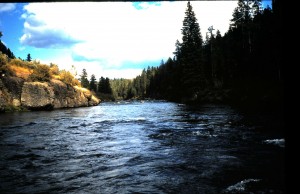
That picture above looks like Box Canyon on the Henry’s Fork,  doesn’t it?  It is taken on Fall River just a few miles below the Idaho-Wyoming border.  To be exact, it was taken between the Boone Creek confluence and the Yellowstone Canal Diversion, the farthest upstream  irrigation take-out on the river.   Fall River in its reach from Cave Falls to the Kelly Bridge,  the furthest upstream crossing a few miles below this diversion, is mostly isolated.  You will not see drift boats here.  There are no developed launch sites upstream of the picture location, there are at least two waterfalls above that would make a portage necessary, stretches of dangerous water, and no developed boat access points in the area of the bridge.   Once in a while a kayak or raft launched at Cave Falls Campground or at the end of the Steele Lake Road may go through this part of the river, but there are some walk-in access points.   Most are off the Cave Falls Road, but one of the most convenient on public land is off the Ashton-Flagg Road, and it brings one to the Boone Creek confluence.  Look for it after passing on the west end of the road through the extensive quaking aspen grove straddling the Targhee-Caribou National Forest boundary.  It will be the first gated road on the left (north) side after passing the  Squirrel Creek Vista.  Park without blocking the gate and walk the road, a bit more than a mile, to its end near the confluence. The last few yards are a scramble down a steep, but negotiable slope to the river edge.  You will be in Idaho here, but much of the river above is  in Wyoming.  Most folks think of the river here as one long set of rapids holding only small fish.  Not true: within this reach of the river are a number of  large, deep holes that host cutthroat-rainbow trout in sizes that would honor any regional river.  There is one at the Boone Creek confluence, and another about a half mile below.  That one is pictured at the base of the rock outcrop in the picture above.  Walk upstream above the confluence, and you will see more such holes.

The problem with fishing here is the treacherous nature of Fall River. It is notorious for a slippery, rocky bottom. In the early season, about mid June when large stoneflies are emerging, the river likely holds a  high volume of run off.  Safe wading the river then is only for the strong, vigorous angler.  Crossing the river is not recommended for anyone during this time, but if one can approach the water around these big holes, a dry adult stonefly pattern or a deeply presented nymph has a chance of bringing up residents ranging to well over twenty inches.    By mid summer run off is gone from the river (so are mosquitoes!) making it safer to wade the uneven and tricky sub surface. Rely on felt soles and a wading staff.  At this time, and well into September, terrestrial patterns, especially large grasshopper or attractor patterns are the best way to get the interest of the larger trout holding in the big holes.  Large stonefly nymphs and streamer patterns or fly rod jigs will work sub surface.  Because of the isolated nature of the river here and that cell phone service may not get into the canyon, it is a good idea to inform someone that you will be fishing here.  Carry potable water, and be aware that bears are in the area, especially during the August berry season.  If you seek seclusion, wonderful scenery,  a good chance for seeing wildlife, and are in good physical shape, this part of Fall River could end up as a destination for you.

Share

Springfield Reservoir 12-11-10

Our still waters are pretty much iced over now.  Springfield Reservoir is the exception.  Springs at the west end keep this part of it ice free though winter.  The east end ices over.  On nice weekend days the open water becomes quite crowded with anglers trying to remedy cabin fever.  During nice week days the open water is not so crowded.  Pontoon or hard sided boating are the most comfortable ways of fishing here as waters are typically in the high & mid forties in degrees F.   True, most ‘bows present are 16-20″ individuals from recent IDF&G plants, but some very large hold-overs are present.  These are worthy opponents, and the easy access at Springfield makes a great alternative for a trophy during winter time.  These big guys forage on the abundant chub minnows in the reservoir.  Presenting midge pupa and small leech patterns also offer a chance to encounter these fish.

Share

Big Lost River 11-13-10

There is great BWO and midge activity in the river below Mackay Dam.  Flows are low making wading easy,and fish are active.  So get out and enjoy this great little river before winter sets in for sure.

Share

Henry’s Lake 11-13-10

Fish are in the shallows all around the lake, and they are eager to hit flies. Small leech patterns presented on slow sink or intermediate lines are best.  The problem is the weather. It’s gonna be COLD and even WINDY and SNOWY.  So dress and drive accordingly.

Share

Main Stem Snake River 11-13-10

Flows are down to normal or a bit below, so wading is ideal for pitching streamers. Water temps are in the low to mid forties, so dress accordingly.  There are so many good locations the best thing to do is come in and see us to help make a choice.  Be sure to have a sink tip and a floating line equipped with short, stout leaders for presenting your streamer flies. Fish late or early in the day for the best chance to meet a migrating brown.

Share

Henry’s Fork 11-13-10

As with the South Fork dry fly fishing concentrates around BWO and midge life cycle patterns.  Streamer patterns produce best results for wet fly fishing, although bead heads of your favorite small nymphs will produce.    Flows above Ashton Dam remain lower that normal to aid in the Ashton Dam project.  Flows below the dam are also low.  Low flows concentrate fish into deeper water for overhead cover, so watch heads and tails of holes and runs as well as riffles for rising fish.

Share